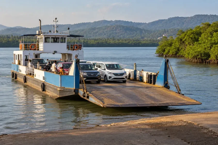
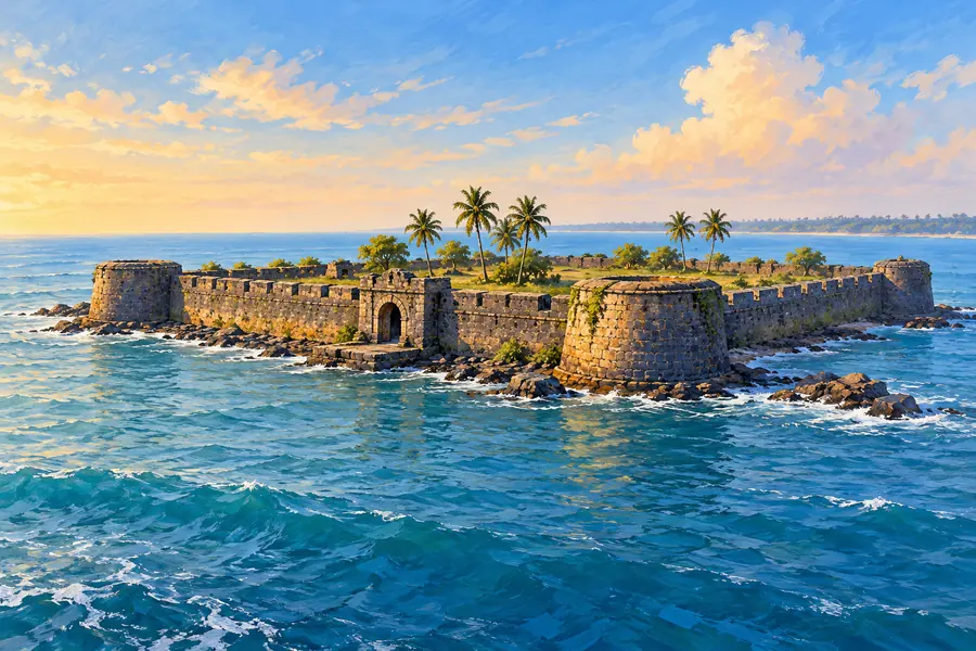
Arnala Fort offers a coastal heritage outing with a distinctive beginning: the fort stands on an island, so the journey includes a boat crossing as well as a walk. That setting gives the visit its character. The water around the island helps explain the defensive role of a sea fort before you even begin looking at its walls.
I recommend planning Arnala as the main experience of the day. Confirm the crossing and return first, then give yourself time to explore a manageable part of the fort. This guide covers the mainland approach, the island visit and the architectural details worth noticing, without assuming that an old ferry timetable or fare is still current.
Arnala Beach and Arnala Fort are different stops
A road journey to Arnala takes you to the mainland coastal area. Visiting the fort requires the onward island crossing and the approach from the landing. Entering “Arnala Fort” in a navigation app should not be interpreted as a continuous road route to the monument.
The Palghar district administration’s Arnala Fort page identifies the fort with the names Jaldurg and Janjire Arnala and describes ferry access from Arnala Beach. It names Virar as the nearest railway starting point for the outing. These are useful orientation details; the actual boarding location and operating arrangements need confirmation before departure.
- Main destination: Arnala Fort, off the Arnala coast, Vasai taluka, Palghar district.
- Rail arrival: Virar, followed by a mainland road transfer and boat crossing.
- Visit style: coastal history, stone architecture and island surroundings.
- Suggested plan: keep a generous half-day window, adjusted around confirmed boats and your walking pace.
This map searches for the fort. It is a destination reference, not a verified ferry terminal marker. Save the current mainland boarding point and island return point separately once the operator confirms them.
Get the crossing details before setting off
Ask whether visitor crossings are operating on your chosen date and which boarding point to use. Confirm the outward and return arrangements, the applicable fare and how much time the operator advises for the island visit. A return plan matters as much as an available outward boat.
Check the weather and follow any local instructions on sea conditions. Services can depend on conditions and operational decisions. Do not base the day on a claim that boats always leave at a fixed interval, or that reaching the shore guarantees a visitor crossing.
Before boarding, clarify capacity, passenger arrangements and available life jackets. Use an authorised service operating under the current local arrangements and follow crew instructions. Keep bags compact and belongings secure so boarding and leaving the boat remain straightforward.
If the crossing is not operating, enjoy a suitable mainland outing or choose another date for the fort. The island visit does not need to be forced into an unsuitable day. Keeping that flexibility makes the planning more comfortable for everyone.
How to reach the mainland approach
Travel to Virar railway station and arrange onward local transport towards the Arnala boarding area. Use the western side for the usual coastal approach, confirming the pickup with your driver. Show the actual boarding location rather than asking to be dropped at a general Arnala marker.
For a bus journey, check the current Arnala connection and the remaining distance from the final stop to the boarding point. An auto or hired vehicle may suit a group that wants one clear mainland transfer. Confirm the fare arrangement and the return pickup before beginning the ride.
The Vasai travel guide explains how to separate the main rail journey from a local connection. For Arnala, add one more stage: the boat. Estimate time for all three parts instead of treating the arrival at Virar as the start of the fort walk.
If driving, navigate to the confirmed mainland approach and follow current parking instructions. Keep room for residents and vehicles using the coastal streets. Save the car’s location, and allow time to walk back after the return crossing rather than scheduling departure at the exact moment the boat arrives.
A useful way to understand a sea fort
Arnala’s island position is the starting point for reading its architecture. A coastal defensive enclosure needed to manage arrival, watch surrounding water and support people inside the walls. Look at the relationship between the gateway, bastions and enclosed ground, rather than seeing each as an isolated photograph stop.
The district description identifies a rectangular layout and an entrance flanked by substantial bastions. From accessible ground, notice how those elements organise movement into the fort. A bastion projects from a defensive wall; its shape helps explain why a fort’s outline is more than a decorative boundary.
The official gallery also identifies an octagonal reservoir. Water storage is an interesting part of an island fort’s story because the sea around it does not provide drinking water. If the reservoir is accessible on your visit, observe it from the permitted edge without leaning over or entering it.
These features give you three questions to take through the visit: how did people enter, how was the enclosure defended, and how were basic needs supported? You can learn something meaningful from the layout without needing a complete list of dates or a confident name for every surviving structure.
What to notice on a first walk
The entrance and the scale of the masonry
Begin with a wider view of an accessible gateway. Include enough surrounding wall to show its proportions, then look at a smaller detail such as the curve of an opening or the texture of the stone. The pair of views is a useful record of scale and craftsmanship.
Keep the group on the normal approach and allow other visitors to pass. There is no need to climb masonry for a satisfying perspective. A photograph taken from ground level can show wall height and depth more clearly than a hurried pose on an edge.
Water storage and the interior
When looking at a reservoir or other interior feature, connect it to everyday life rather than treating it only as an unusual shape. Discuss why a defended island settlement needed supplies and storage. Do not assume that water in an old well or tank is suitable for drinking; carry your own water for the outing.
Choose a short loop through the areas currently open and return along a route you recognise. If a feature is unlabelled, describe what you see instead of guessing its historic use. Clear observations make better memories and captions than uncertain claims.
Religious spaces and the living island
The island visit takes place in a living setting as well as a heritage one. Respect worship spaces, local routines and private property. Ask before photographing people, and keep routes through residential areas considerate.
If a religious space is open to visitors, follow its footwear and photography instructions. Allow your companions time to pause if they wish. A respectful visit can bring the architectural and community aspects of the island together without turning residents into part of a sightseeing display.
A flexible half-day sequence
Begin by reaching the mainland ahead of the confirmed crossing. Check the return arrangement again before boarding and keep the operator’s meeting instructions available. Organise belongings before the boat arrives so the group can board together.
On the island, learn the return landing location first. Walk to the fort by the current public approach and choose a modest exploration loop. Give most of your time to a few accessible features, with a water break before the walk back.
Set a time to leave the fort that includes the island approach and a waiting buffer. Do not plan to reach the landing at the final possible moment. Once back on the mainland, take a meal break or return towards Virar according to the transport arrangement you made.
For a mixed-age group, the family outing guide for Vasai can help you decide whether a multi-stage island trip fits everyone’s comfort. If boarding, walking or waiting needs special consideration, confirm that before choosing the day.
Photograph the island setting thoughtfully
Try a small visual sequence: an overall view of the coastal setting, a gateway photograph and one close architectural detail. Keep the camera secure during the crossing, and take pictures only when doing so does not interfere with boarding or crew instructions.
At the fort, use an opening to frame the sky or include a low wall in the foreground to give a wider image depth. Keep horizons level when the sea is visible. A companion can show scale, provided they are comfortable being photographed and remain on accessible ground.
For captions, separate confirmed names from impressions. “Gateway at Arnala Fort” is enough when you cannot identify a particular entrance. An artistic cover or edited image should likewise be described honestly, rather than presented as an exact record of the monument.
Food, packing and the rest of the day
Carry drinking water, a snack, suitable footwear and protection for the expected sun or rain. Keep packaging in a bag and bring it back to the mainland. Confirm any facilities you need before the crossing and do not rely on an unverified shop or refill point on the island.
Plan food around the mainland return. The Vasai family restaurant guide gives options if one fits your later route, but the listed outlets are not all near Arnala. Compare the actual address before adding a restaurant to a Virar-based outing.
For another heritage visit, the Vasai Fort guide offers a land-based alternative with a different layout and history. I would give each fort its own outing rather than rush between them. Arnala is most rewarding when the crossing is settled, the walk is unhurried and there is time to appreciate how the island setting shapes the fort.